
 |
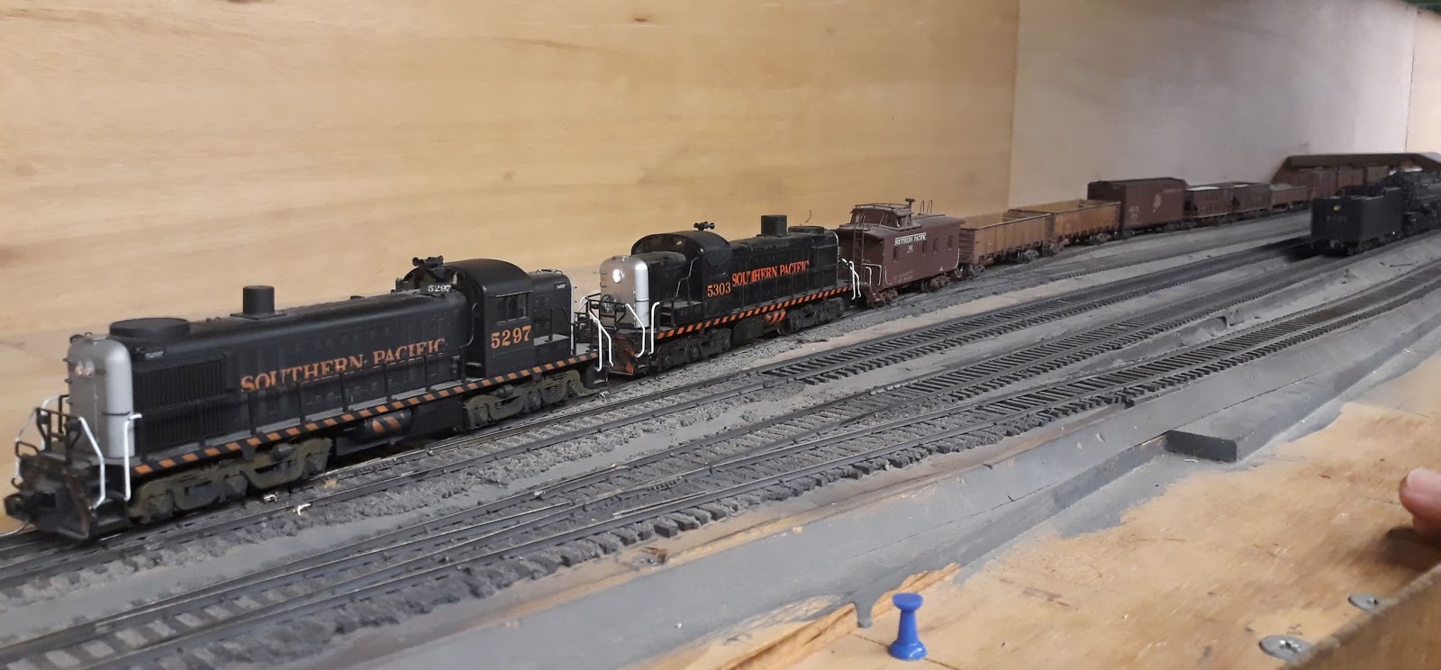
| Two AC's helpers head west light as SP 5297 & 5300 working the KI (Tehachapi) Local switch the sheds just west of Hayes St. at LMRC |
The town of Tehachapi during the 1950's had about 1,600 residents in 1950, but it was one of the largest villas during that era. Mojave only had 2,000 residents! Bakersfield had only 34,000. That said, let's have a look at what businesses existed along the Southern Pacific mainline between Tehachapi Blvd and H Street.
Potato sheds dominated the early on-line businesses along the SP & ATSF Joint Line. However by the 1930s the seed potato business was dropping off, resulting in the agriculture moving to diversify the growing acreage to include fruit and even blue grass seeds by the 1940s.
Town of Tehachapi - General Layout
The starting point before we're able to get the Val Map and Aerial photos started with a rough diagram (below). Summit crossover is shown at the far left (east) end of this diagram supposedly two miles away.
Tony Anderson, the LMRC's Chief Engineer, planned Tehachapi to be somewhat compressed with the primary focus being on the length of Siding Nos. 1 & 2, to accommodate our standard length freights while waiting for orders and meets with opposing eastward trains. The other main issue was the total tangent length between the west switch at Tehachapi and the east switch at Summit Siding, where eastward trains could be clear of the main and detraining their helpers on the wye.
The industries in the town of Tehachapi were therefore a distant third place during the considerations of scale compression and use of the available space. Basically being stuffed into what was left of the two mile prototypical tangent between Tehachapi and Summit, and along the south side of the Main Track west of the Depot.
 |
| 2017 vintage diagram of Tehachapi industries. (Note this is looking south, as on the layout's perspective). |
The drawing above shows the original plan for the industries from about 2015, before I really started digging into what was there. In this version there are no industries on the north side of the mains east of Green St. No.3 Siding is stub-ended. There is also no stub track off the west end of the House Track. Also notice that the spurs between Green Street and Hayes St. are staggered at the west end to lap around the House Track's east switch.
We found these photos on-line, this is the link http://mil.library.ucsb.edu/apcatalog/report/report.php?filed_by=C-18085 - reproduced here in part under fair use.
 |
| Fairchild Aerial Survey Inc photo of Tehachapi to document the earthquake damage on July 25, 1952. - Looking roughly North |
Looking in depth at the Tehachapi July 1952 Fairchild aerial photos, we can see the true layout of the town's industries and buildings. There are a noticeable number of rail-served industries along the NE section, east of Green Street. Several sheds along the double-ended spur, which the selective compression has cut to about 3-4ft long, with not options of lengthening it without pushing the east switch east of the Summit crossover, which of course is not acceptable. One of our main goals is not having any track features of one station in the area of the next station! We'll be limited therefore having the north double-ended spur will only have room for one, maybe two sheds, not the three plus, from the prototype information.
The following CAD diagram shows the redesign and positions of the industries from February 2020. I'll be using this diagram cropped for each of the following detailed discussions.
 |
| Yes, it's a little small... click on it to view full size. this is the CAD model from February of what we can do in the LMRC's space. (Note this is looking south, as on the layout's perspective). |
On the railroad, Tehachapi is the west end of the double track (D-251) out of Mojave. The station has three westward sidings. Siding Nos. 1 & 2 are for westward trains to dive into while waiting for Train Orders to move west. Siding No.3 is shorter and was used for pickups, setouts, and helpers to gather up and wait for orders before heading to Bakersfield. I should take a moment to also reference that the station of Summit is two miles to the east on the double-track with an eastward siding of over 70 cars and the wye to turn helpers.
Businesses, Industries, and Trackside Modeled Structures
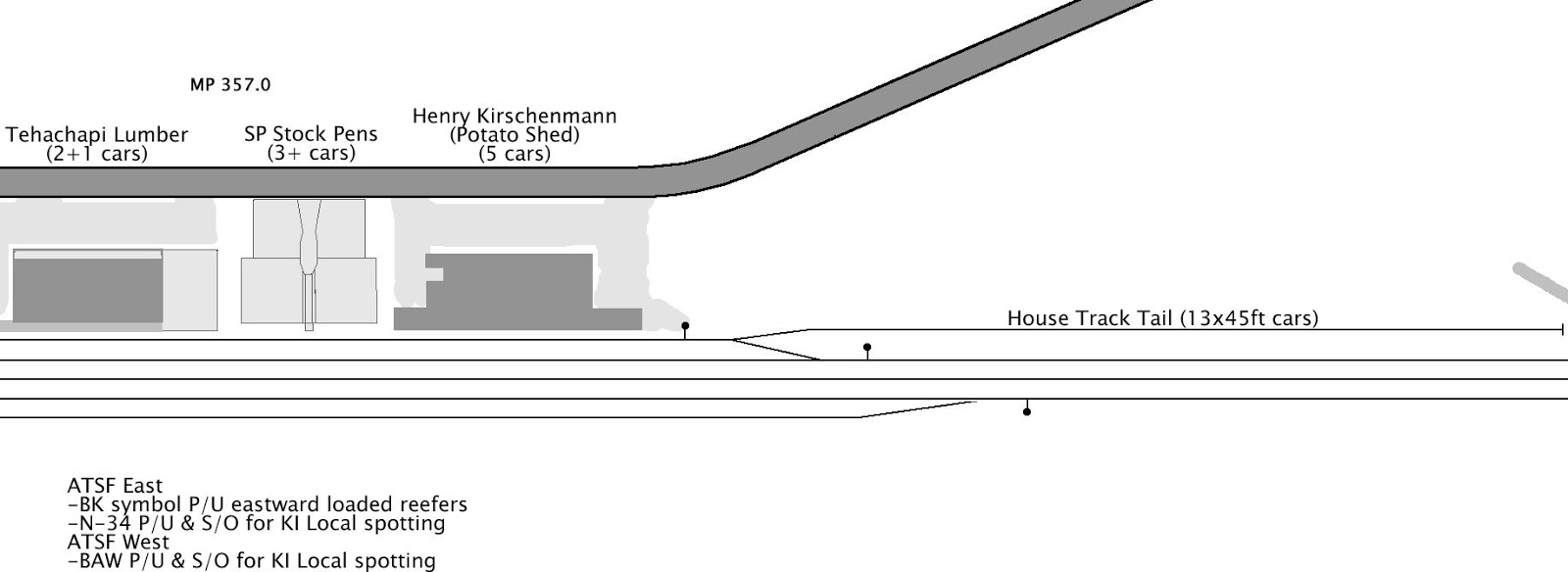
Starting at the west end of town on the south side of the main track there is a double ended siding which serves as the house track. From the west switch, the east the structures were as follows:
West of 400-block of W. Tehachapi Blvd.
There appears to be a stub track which runs down literally in the weeds west of the industries and the west end switch (far right in above aerial photo) of the House Track. It runs to just short of the trestle at MP 356.4 (at the left in the aerial photos below).
 |
| West of the industries at Tehachapi there is a stub track 'down in the weeds' on the south side of the main track. |
I would guess that this spur was used as a place to put "Off Spots" or possibly MOW outfit cars. In further ponderings during the January 2020 TT/TO session, the idea was also floated that this spur might have been used to shove all of the spotted cars out of the House Track to the west by an eastward freight to get access to the stock pens, which would be a priority move over whatever cars were sitting in the house track at the lumber yard, depot freight platform, or packing sheds.
400-block of W. Tehachapi Blvd.
 |
| Henry Kirschenmann warehouse - West House switch is a few hundred feet to the west. |
A Large Packing Shed owned by Henry Kirschenmann. This structure was probably a packing shed. From some other research about Tehachapi, there originally were a large number of seed potato sheds, but during the 1930s much of the agriculture shifted to fruit, with only a small amount still working with potatoes.
Southern Pacific's Stock Pens
This stock pen measures about 112ft along the tracks, with two 50ft pens and two 41ft long pens. In one set of data we have shows the pens existing, but the location of the next shed to the east seems to flip position by about 120ft.
 |
| Tehachapi SP Stock Pens - possibly removed between 1947 and 1952. - Except from SP Val Map |
The aerial photos from Fairchild do not show the stock pens there in July 1952, but replaced with the Lumber Yard.
300-block of W. Tehachapi Blvd.
 |
| Tehachapi Lumber Yard and Shed - Aerial photo July 1952. - |
225 W. Tehachapi Blvd -
Tehachapi Lumber shed and yard. This building currently still stands as 'Auntie Em's Antiques'. Some of our research is confusing on the relation of this building and its lumber yard to the stock pens to the west, which once dismantled became part of the lumber yard.
Revised LMRC Map
 |
| West Tehachapi CAD scale drawing - Jan 2020 (Note this is looking south, as on the layout's perspective). |
Here's the detailed revised Jan 2020 Scale Drawing of what the west end of Tehachapi looks like after compression is applied. The west end switch of Siding No.3 was not originally planned to be built, so this will require widening the benchwork for about 36" and installing the new switch.
The west switch of the House track was originally planned to have a split-point derail protecting the main track. Thankfully the derail was not finished when we found the aerial photo showing the stub which extended off from basically the same point where our derail was supposed to go. This allows us to easily change the ties pattern to that of a full switch and install some new sub-roadbed for the House Track "Tail". The "Tail" spur will also drop down about 18-24" in elevation to be 'down in the weeds', per the aerial photo, which shows the shadows of the rails and even the exposed ties! The Tail's length is adjusted with selective compression to proportionally match the distance from Green Street to the west end switches of Nos. 1 & 2 Sidings.
200-block of W. Tehachapi Blvd.
 |
| "Summit Farms" which may have dealt in Blue Grass Seed after the potato market dried up at Tehachapi. |
Around 200 W. Tehachapi Blvd. was a smaller building which was probably a moderate sized packing shed. This structure had a very interesting 'ad-hoc' construction style with many small extensions added on over the years it would seem.
This is probably Summit Farms dealing in blue grass seeds, but there still needs to be more confirmation from the 'old timers' and the Tehachapi department of commerce.
100-block of W. Tehachapi Blvd.
 |
| SP Tehachapi Depot at lower left in this crop of the aerial photo from Fairchild. It appears there is a business car and a couple freight cars at the freight platform. |
125 W. Tehachapi Blvd.Another larger shed which still stands as "Kohnen Country Bakery". This building was originally a packing shed, as some of the details still clearly show. Drawing from some of our ATSF customer list for the town of Tehachapi, we're guessing this was "Hi Valley Orchard" which probably by the 1940's was dealing in apples.
I believe east of that was a small gas station, which we're looking for confirmation on, but it could just be a garage or shed.
101 W. Tehachapi Blvd. is the SP standard station, which was about 114' long between the western edge of freight platform and the eastern wall of the passenger end of the structure. The spring crossover at the end of double track is just west of the Station. On each side of the station is a water column about 170ft away. The eastern column was used to fill the tenders of eastward passenger engines during their station stops. The western column was between the No.2 and No.3 sidings which allowed the returning westward helpers to top off their water after helping freights up the grade and turning at the Summit wye.
 |
| SP Depot at Tehachapi - Still needs some reworking. - Jan 2020 (Note this is looking south, as on the layout's perspective). |
The 1950's era station was destroyed except for the eastern wall one year short of it's 100th birthday by arson fire. The town of Tehachapi pulled together to rebuild the station in under a year, in time for the 100th anniversary celebration!
 |
| Tehachapi Station, Green Street and sheds just to the west. - CAD Jan 2020. (Note this is looking south, as on the layout's perspective). |
Here's the revised Scaled CAD drawing for the center Tehachapi area from Jan 2020. Unfortunately laying out this version of the drawings, with the water column between Siding Nos. 1 & 2, requires tearing out the switch between the east end of Siding Nos.2 & 3 and moving them north a couple of feet.
Green Street Crossing
Green Street is the western grade crossing in town.
100-block E. Tehachapi Blvd.
 |
| Detail of the 'company village' just east of Green St. - Fairchild Aerial Survey |
In this detailed view we can see the depot at the left and collapsed water tanks center bottom, between the track and Tehachapi Blvd. The large number of water cars (three red and two black) are supplying the town with potable water after the pipes were damaged between Woodford and Tehachapi.
Immediately east of Green Street is a small gas service station on the NE corner of Tehachapi Blvd. and Green Street. Tehachapi Blvd runs just in the backdrop on the layout, so we'll be able to model about 85% of this gas station. As of 2019, this gas station is long gone. A small mini-strip mall with County Real Estate is built on the lot.
East of the gas station is the Southern Pacific's company water service tanks and also the town's supply of water, which was provided by the Southern Pacific's infrastructure. The water tanks collapsed during the July 1952 7.5 Magnitude "White Wolf Earthquake." Many brick walls of the structures along Tehachapi Blvd were damaged during the quake as well.
The water tanks were replaced quickly in time for the reopening of the railroad 25 days after the quake. We'll be modeling the two pump houses and two water tanks. The water tanks often had 2-3 water service tank cars spotted in front of them between Green Street and the east house switch.
The prototype alignment had a crossover immediately east of Green Street, allowing a pocket for the water cars. The modeled version of water track has lost this additional crossover simply because we don't have the space for it.
 |
| Company Village (at right) which we'll be compressing. |
East of the water tanks was a small "company village" and section gang housing. Unfortunately our model will only be able to have one standard bunk house.
300-block E. Tehachapi Blvd.
Two spurs on the south side reach just past the shed at 333 E. Tehachapi Blvd. and stop short of the drainage ditch. The spurs are accessed by a switch just east of Hayes St. with the closure rails of the 'inside' spur switch crossing in the road at grade.
 |
| 333 E. Tehachapi Blvd at the left in the aerial photo above. The spurs are full of what appear to be ballast and side-dump cars related to the work que for the damaged Tunnels near Bealville. |
333 E. Tehachapi Blvd.
A small culvert ducks under the tracks between the company village and 'The Apple Shed", which is currently known simply as 'The Shed'. We're having some compression between this and the next shed to the east, as well as compression to about 80% in track-side length. On the 'Val Map' we have this shed is shown as "Jacobson Bros.", which I would assume is resolved by the Jacobson Bros owned "The Shed".
What messes with me a bit is that at some point I thought 'The Apple Shed' was the building at 125 W. Tehachapi Blvd, which is now the "Kohnen Country Bakery." I'm not sure if they were different businesses or what.
400-block E. Tehachapi Blvd.
~425 E. Tehachapi Blvd.
Oddly this structure is shown on the Val Maps as owned by "Emil Kirschenmann." So not sure why Henry owns the shed on the west end of town and Emil owns the one on the east end. Continuing to look into information of what the business names were for the sheds. - See right side of prior aerial photo above.
 |
| The most compression is applied between the water tanks and the single bunk house. (Note this is looking south, as on the layout's perspective). |
Here's the revision to the CAD model scaled to fit the LMRC layout space - CAD Jan 2020. The Fuel Dealer from the 2015 version, is moved across the mains to the north side, and the pair of spurs on the south side are planned to be cut off even as a small creek drainage needs to exit the right-of-way to the south between the west end of the pair of spurs and the company village.
The Company Village on the south side is massively compressed and the water systems are compressed to the limits of their infrastructure. We will only have room for one bunk building, not two. The two water towers are signatures of the town of Tehachapi, so we've got to have them! The prototype's left-hand crossover just east of Green Street from the House Track to the Main Track, which created a small 'water track' pocket to keep water cars in is removed. Any MW Water Cars or supply cars unloading water treatment compounds will have to be switched with the whole House Track.
Hayes St.
The eastern grade crossing in town is Hayes St. which has the switch for the two spurs on the south side right in the crossing. The two main tracks cross Hayes St and on the north side, there's an a double-ended spur.
North of the Main Track
 |
| East of Hayes Street were several more industries, which will not be modeled at LMRC due to the compression in this area. |
On the other side of the main track, we'll work back to the west. First off, the major compression is loosing about 2500ft of double-ended spur. The result is that we only have room for one or two of the three or four graineries.
500-block E. H Street.
We'll have about one or two car spots to be able to have the 'bin' and 'shaft' structures for the grainery at Tehachapi Supply Co. This will be squeezed in just east of Hayes Street.
400-block E H Street.

Tehachapi Hay & Grain will be moderate sized warehouse of about 70ft and an extra 28ft extra platform on the west side along the track.
401 E. H Street.
 |
| 401 E. H Street is at the top right of this cropped view of the Aerial photos. |
There is a possible Bulk Fuel Dealer at this lot, today it is a School Bus Depot, in the aerial photos from the 1952 earthquake survey it appears to be more of a fuel dealer with several tanks and small buildings. 401 E. H Street is actually on the north side of H Street, but on the model we simply don't have the depth in the benchwork to cross the small dirt road. Therefore we'll have these small fuel dealer buildings just north of a stub track north of the double-ended spur along the edge of the benchwork.
300-block E. H Street.
 |
| As the spur from the fuel dealer diverges to the upper left (North East), there is a pair of company dwellings and a small Supply Yard along the spur. |
West of the fuel dealer, the SP had an MOW Supply Yard and some "Company Dwellings". The prototype had another spur, but because of the depth compression this spur will have to be omitted. Again several hundred feet of additional material yards have to be omitted between the dwellings and Green Street.
West of Green Street between the mains and H Street there was basically open with no industries.
 |
| North of the Main Track industries compressed to fit between the main and the operators' aisle. - CAD Jan 2020 (Note this is looking south, as on the layout's perspective). |
The last section of the selective compression scaled CAD model from Jan 2020. Much of the compression here happens between Green Street (at right) and the Company Village. The Fuel Dealer can't be a block to the North on the other side of H Street, so that spur has been consolidated and moved against the double-ended granary track.
The creek bed shifts slightly under the mains to create a bit more space for the rearranged Bulk Fuel Dealer and MW Material Yard, as we'll be removing the whole 'inside' spur, with again, we just simply won't have room for.
Other Notes on Modeling Tehachapi
Here's the complete un-cropped selective compression CAD model from January 2020.
|
| Enjoy looking over the revised compression drawing from early 2020. (Note this is looking south, as on the layout's perspective). |
While it would be 'fun' to be able to model Tehachapi without any compression, that just isn't going to happen. At the end of the day, the public will never be able to see this section of the layout as it will be behind the Marcel-Cable backdrop wall. So we're doing the station to meet the demands of the road freights needing to use Siding Nos. 1 & 2, and beyond that, we're doing this 'for ourselves'. As such, we're modeling the traffic options representing what went in and out of Tehachapi during the WWII-1960 era. Therefore at least one of each industry type to spot our cars at is the main issue to be addressed and then making it look as close as possible. I think we've done a pretty good job balancing this all out.
Unknown Shed Names
Other business names which we're researching where they go:
- Summit Farms - possibly one of the sheds west of the depot... but that's as far from the "Summit" as you could get... so not sure.
- Hi Valley Orchards - possibly Jacobson Bros?
- Apple Shed (possibly the same as "The Shed")
Wrapping Up
 |
| January 2020 brought the ripping up of the East No.2/3 switch to be realigned. Here the work is overseen by the Section Gang and some outfit cars. |
This is just the first in a series of future posts as the club moves our model of Tehachapi past the 'plywood and rails' phase.
Jason Hill
Related Articles:
West Bakersfield (Part 1) - Laying Out Industries
Tehachapi Operations (Part 1) - "Mountain Work Train" Symbol
Tehachapi Operations (Part 2) - "Mojave Shorts" Symbol
Freight Symbols Over Tehachapi Index
No comments:
Post a Comment
Please identify yourself at the end of your message. Please keep comments relevant to the post or questions to me directly.
All comments are moderated and must be approved, so give me a bit of time to approve them.
No random solicitation in comments. Spamming and phishing comments will be deleted or not allowed to post.